
Arun Valley: Arundel to Amberley, West Sussex
A country walk in the Arun Valley: Arundel to Amberley
This country walk connects two historic and charming Sussex settlements on either side of the Arun Gap, which was cleaved by the River Arun on its way through the chalky South Downs ridge. This linear, station-to-station walk follows the river for much of the way before heading up into open downland for brilliant views and stacks of wildlife. Highlights along the way include the brooding hulk of Arundel Castle and, to our mind, one of the best pub lunches to be found in all of Sussex.
Starting point: Arundel, West Sussex (an hour and 20 minutes from London by train)
Last hurrah: Amberley, West Sussex
Distance: 7 miles, 3-5 hours
When to go: all year. This walk is short and straightforward enough to fit into winter days, or come in summer to take advantage of picnics, cricket, blue skies and birdsong.
Difficulty: This is an easy and straightforward walk along an elevated riverbank and downland tracks that are wide and sturdy enough to carry farm traffic. The valley bottom can get sodden in winter but the route is otherwise rarely too muddy.
See the map for this walk here: https://www.outdooractive.com/en/route/hiking-route/wkndr-arundel-to-amberley-via-burpham/204097495/
You’ll need to create an outdooractive profile to view the route, then hit ‘Open in App’ on your mobile phone to follow the route using GPS.


Directions: From Arundel station, take the main exit and turn immediately right (before the taxi office) into the underpass. Follow this traffic-free route to the town centre, whose twin landmarks - the Cathedral on the left and magnificent castle on the right - frame the scene. Cross the river and stay straight ahead to reach the town's main square. Pause to admire its mix of Georgian and Tudor townhouses, then pop into Pallant of Arundel to pick up some savoury snacks from the deli.
Retrace your steps back over the river and follow the footpath signs on the left to the riverbank. The rickety wooden jetties that line the riverside hereabouts serve as a reminder of long-ago times when Arundel was a port. From here, the river sweeps inland. Look back frequently as you progress to admire Arundel Castle silhouetted against the sky. Its impressive façade only dates from as recently as 1900, but at its heart this castle is ancient indeed: its motte (fortified mound) dates from 1068.
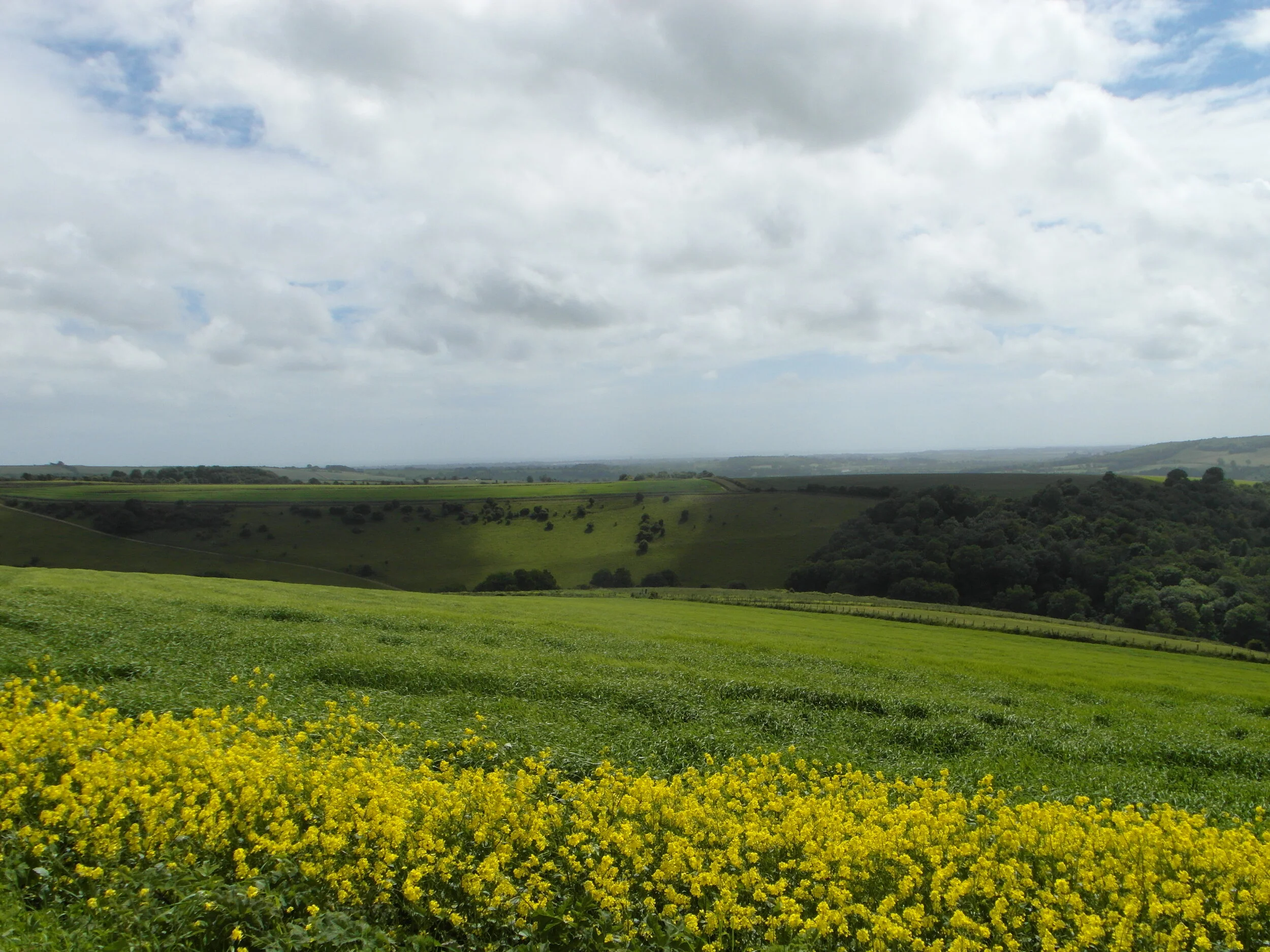
The water meadows that fill the flood plain are an important wildlife habitat. Water voles (a threatened and declining species) have a stronghold here, but they're not all that easy to see. Look out for more obvious sights like swans and snow-white egrets, and don't be surprised if an electric-blue kingfisher flashes past on the river, announcing its presence with a shrill, high-pitched whistle.
Where the path almost touches the railway line by an isolated house on the valley's east side, stay on the river as it meanders lazily through the full width of the floodplain, reaching all the way to the western flank opposite (but tantalisingly out of reach of) the Black Rabbit pub. After the river bends back east (and just before the railway bridge), leave the elevated bank and follow the path across a corner of the floodplain to reach a level crossing. With a last look back at the castle (and listening carefully for oncoming trains), cross the railway line and pass through a meadow to rejoin the riverbank. Press on towards the village of Burpham, which you'll see half way up the hillside ahead.
When the riverbank path meets a steep, wooded bluff before curving back across the valley, ascend the set of steps ahead and follow the path to Burpham's cricket pitch, above which looms the squat, flint tower of 12th Century Burpham Church. On the other side of the pitch lies The George, a cosy, community-owned country pub with exceptional food (including legendary roasts on a Sunday) served either on trestle tables outside or by the fire on wintry days.
After lunch, head into the churchyard and turn right (before the church), past the gravestones and over the wall into a field. At its far end, the path meets a single-track lane: turn left and follow it up to a farm and beyond to where it morphs into a cinder track. Where this splits just past the farm, bear left on the bridleway and stride out into open South Downs scenery.
Owned by the Duke of Norfolk (whose home, Arundel Castle, can once again be seen on the left, back across the valley), this estate is a mixture of arable fields and unimproved chalk grassland that is managed in a sustainable way that's sensitive to wildlife. Miles of hedgerows have been planted, pesticides are kept to a minimum and strips of seed-rich cover are kept at the edges of the fields. As a result, it's full of life. Listen out for the 'creaky gate' calls of grey partridges, mewing buzzards and kronking ravens (and if you're here on a winter afternoon, there's a good chance of seeing owls).
Stay on this chalky path as it loops past a patch of scrub and then round to the left, past another farmyard before descending into the valley towards the hamlet of North Stoke. Where the path splits halfway down, take the right fork and plunge straight ahead on a bridleway into the trees, then turn right at the bottom onto a single-track lane. Now it's just a case of following this track all the way to its end, where it T-junctions at a road.
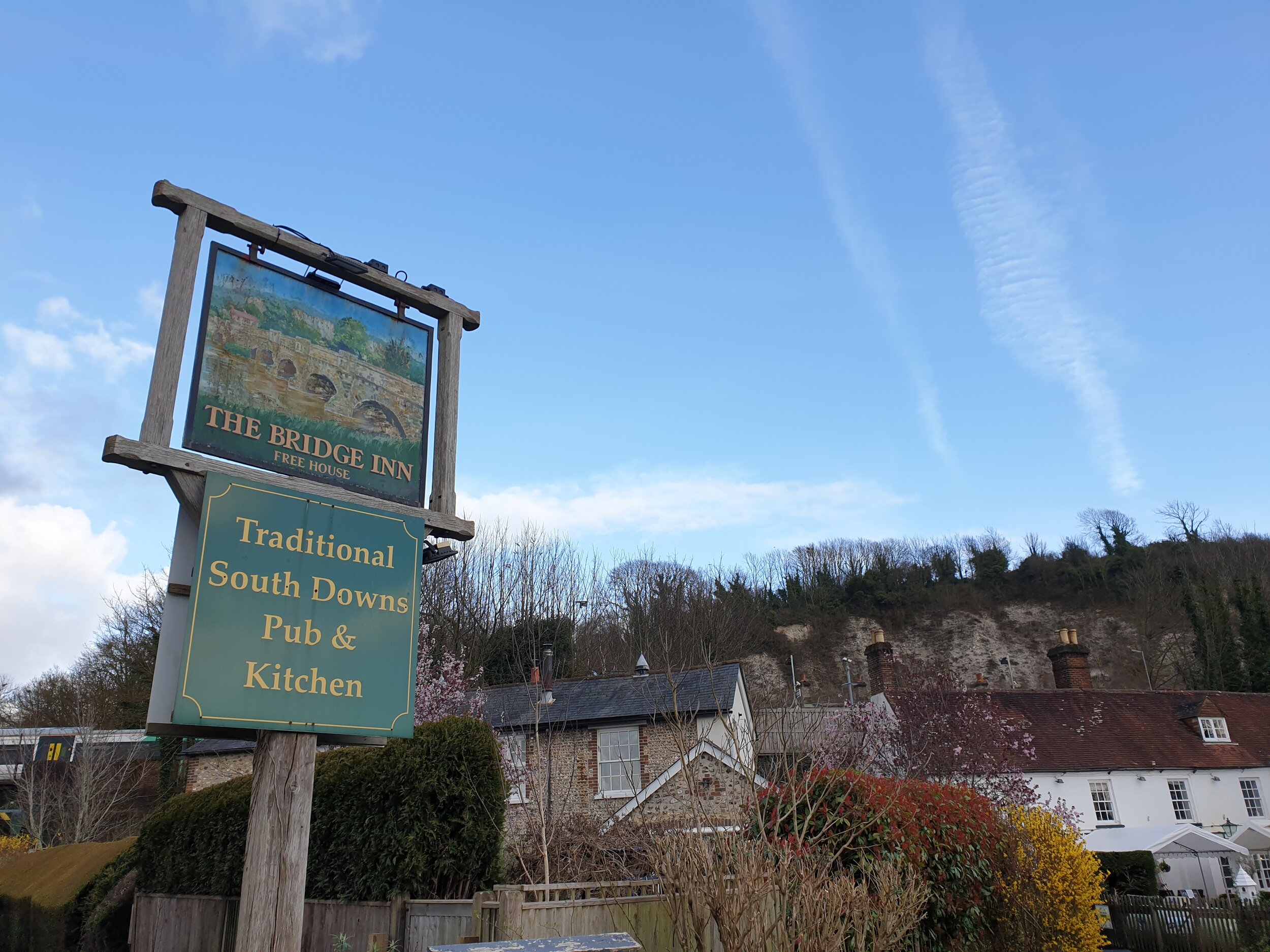
If you're not in a rush for the train, take a break at the lovely Bridge Inn for a pint. Skip the mainstream brews and order instead a local Sussex ale (try the Harvey's Sussex Best Bitter, from the East Sussex town of Lewes, or a Langham golden ale from a few miles away in Petworth). Then when you're ready to hit the road, it's simply a case of turning right to pass under the railway bridge, then right again into Amberley station for a chilled-out train ride back home.
Start planning your journey with www.thetrainline.com