Ouse Valley Viaduct, West Sussex
A country walk to the Ouse Valley Viaduct
Set between the North and South Downs, the High Weald is one of England's finest landscapes. A designated Area of Outstanding Natural Beauty, its hundreds of acres of woods, heaths and farmland are spread across three counties. Take in a good mix of its scenery on this linear, station-to-station walk that's easy to access thanks to both stops being on the busy London to Brighton train line. In addition to spirit-lifting countryside, the highlight here is the Ouse Valley Viaduct - a masterpiece of Victorian architecture that's an Instagram sensation.
Starting point: Haywards Heath, West Sussex (45 minutes from London by train)
Last hurrah: Balcombe, West Sussex
Distance: 7 miles, 3-4 hours
When to go: best in summer, when conditions underfoot are dryer. In winter, some paths become so muddy as to be almost impassable unless you're wearing wellies or waterproof boots
Difficulty: This is a fairly straightforward route (muddy paths notwithstanding) with several hilly climbs and quite a few stiles to negotiate
See the map for this walk here: https://www.outdooractive.com/en/route/hiking-route/wkndr-ouse-valley-viaduct/204233260/
You’ll need to create an outdooractive profile to view the route, then hit ‘Open in App’ on your mobile phone to follow the route using GPS.


Directions: Exit Haywards Heath station past the Waitrose (stop here for snacks and provisions) and cross the road to the roundabout, then turn left onto Mill Green Road. Where this ends at a T-junction, turn right and then immediately left into leafy Wickham Way. At the top of the hill, turn right into what looks like a private driveway (don't worry, it's a right of way) and then left downhill on a footpath through the trees. The towering oaks and limes with their understory of holly and hazel are typical of the Wealden woods that dominate this region.
After crossing a small stream, the path heads uphill again to emerge on a golf course. Keep going straight ahead past the fairway and plunge into another patch of trees between sections of the course. Where the path reaches the 14th tee, take the sharp left turn down the hill through a woodland of oak and chestnut (it's a riot of bluebells in springtime).
At the bottom of the hill, cross the lane and continue on a path marked High Weald Landscape Trail until it opens onto a paddock. The gate here is one of the spots that can get waterlogged in winter. Head up the slope ahead and pass through a kissing gate into a farmyard, then cross the stone bridge over a disused railway line and on through another kissing gate into more woods. The path ahead eventually leads down through the forest to another paddock in a flat-bottomed valley carved by the River Ouse (though here it seems little more than a stream).
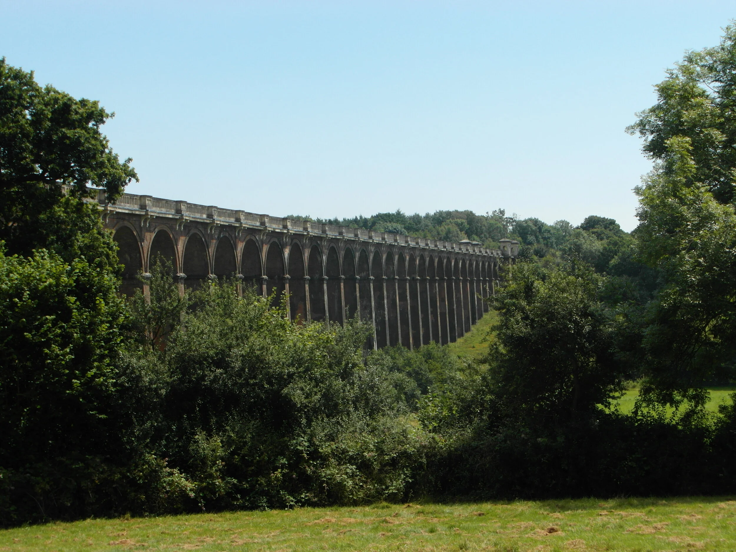
Turn left and walk upriver along the level ground of the valley. A bend in the river reveals your first view of the Ouse Valley Viaduct as it marches across the landscape ahead on its 37 elegant arches. Keep going to where the path meets the road, then turn right across the river and take the footpath on the left across the field to the top of the viaduct.
Completed in 1842 as part of the London-Brighton railway, the structure contains some 10 million bricks that were brought to the site on barges floated up the Ouse. It looks pretty special from any angle, but the real treat comes once you stand underneath and look down its full length. In the builders' thrifty eagerness to economise on bricks, the hollowed-out design of the viaduct's 100-foot-high supports turned this utilitarian structure into an architectural triumph. Their perfect symmetry creates an amazing optical illusion that challenges the viewer's perspective. It's quite extraordinary.
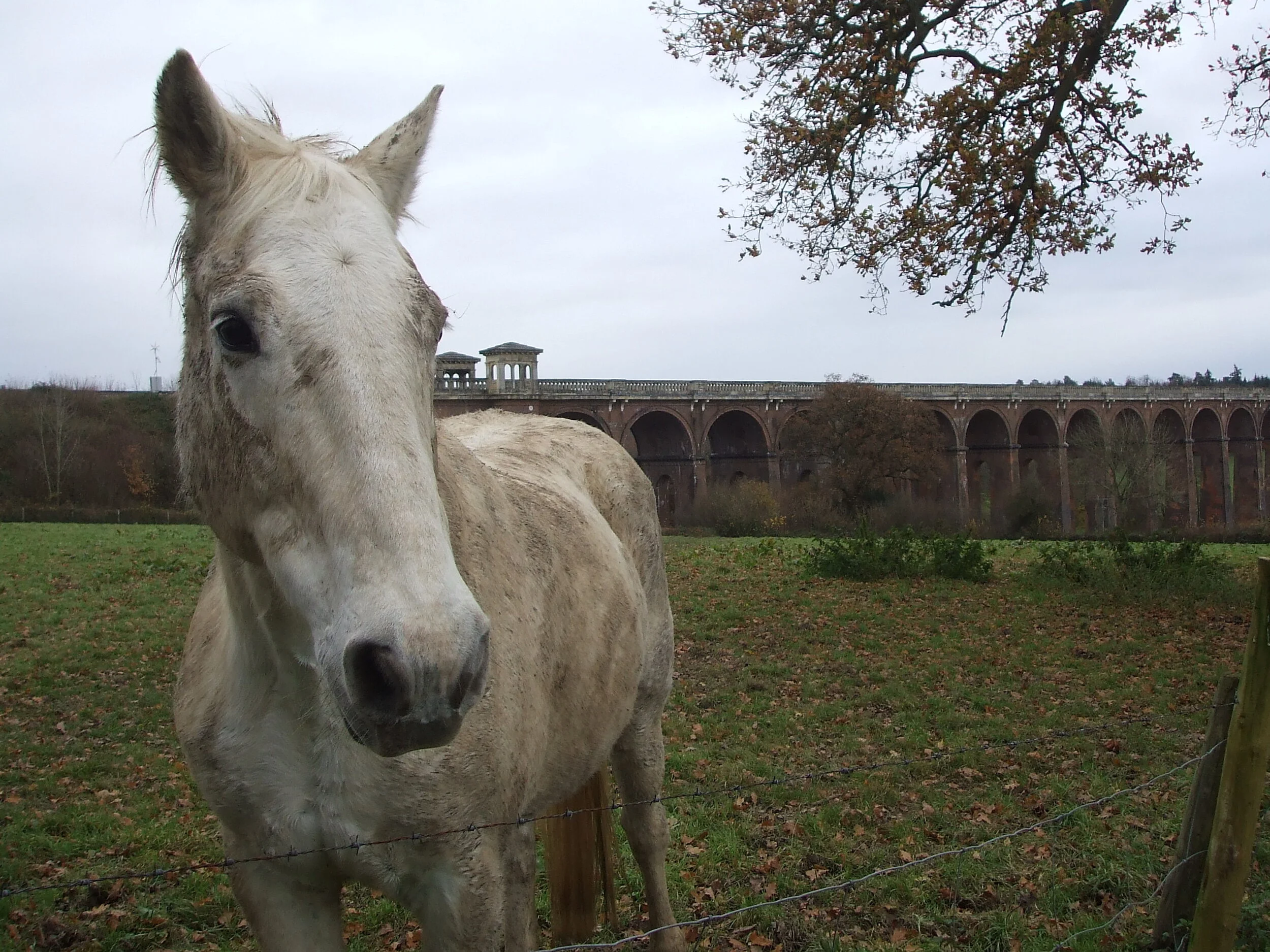
Once you've taken the obligatory pictures, continue up through a small field. At the gate on its far side, look back for a splendid last glance at the viaduct (ideally with a train rattling across). Carry on through a farmyard, after which the footpath enters a field to the left. Follow along the hedge at the top of the field and then cross a pair of stiles before heading diagonally down the slope of the next pasture. The stile here takes you back to the banks of the river. Cross the wooden bridge and go straight ahead on the path that hugs the hedgerow. At the farm, turn right onto a paved track and follow it as it winds across the floodplain, paralleling the river all the way to the road.
Cross over and take the right turn into Cherry Lane, following it up the gentle slope and down the other side, at the bottom of which cross the river again and take the footpath on the left to a hilltop cottage. Pass the cottage and continue over the crest of the hill before descending past a distinctive sandstone cliff. Follow the signposting straight ahead where the footpath crosses another, heading down a steep slope and over a wooden bridge that crosses a gully.
On entering the field beyond, skirt left and follow the path up the slope and over a stile until it hits the road. Cross over and take the immediate right onto a paved drive to a manor house. At the end of the track, veer right and round to the left through a gate that leads onto the railway. Cross over the bridge and take the trail uphill to the outskirts of Balcombe. Keep going straight ahead and pass the football pitch on your way to the village centre, where you'll find (to the left) a forgettable pub and the excellent Balcombe Tea Rooms. The two jolly ladies that own it serve up home-cooked treats such as roasts and lasagne, plus the likes of club sandwiches, soups, egg and chips, and too-good-to-miss scones and cakes.
When you're too full to eat any more, push on down the hill and turn left onto London Road, where you'll find Balcombe station further down on the right.
Start planning your journey with www.thetrainline.com